Open the mailbox the other day, and this letter arrived in the mail. It tells me I have been assigned my 46'er number! Stated number - 6764! I like it, because I was born in '64, so it fits the whole 46/64 theme. After basking in this temporary glory, I began to think about the next goal. Besides the beginning of the second round of 46, reading the ADK forums has renewed the fire in me to complete the winter 46. So, with a run of seven days off coming up in a couple of weeks, it's time to increase the winter number. I currently have completed 8 winter peaks in the course of doing the original 46. they are, in Order so far - Algonquin, Iroquois, Street, Nye, Tabletop, Lower Wolfjaw, Redfield and Wright. My thought, since I am so woefully out of hiking shape right now, is to start easy with Cascade and Porter, take a couple days rest, then hit Cliff or something similar to try to ease my way back into hiking shape. Thoughts of the toughies nibble at the back of my mind (Allen, Santononi's and the Sewards) but I need to complete this goal! I will also continue to add to round 2 of the 46, complete the fire tower challenge along with this goal, and also Mount Washington is on the radar for this spring. Off to the gym to start shaping up!!!
Just a reminder, this blog is in chronological order as far as mountains go. There are a few miscellaneous posts at the end. It starts with Rocky Peak Ridge in 2005 and ends with Colden in 2010.
Saturday, February 26, 2011
Sunday, April 11, 2010
Rocky Peak and Giant - 5/28/2005

This is my new Blog to share with friends and family my adventures of attempting to become an Adirondack 46er! I will share with you photos and commentaries on my ongoing attempt to climb the 46 tallest peaks in the State of NY. The photo at right was my first high peak conquest in 2005. The 2 peaks were Giant and Rocky Peak Ridge. This particular photo is me on Rocky Peak. These are the mountains that gave me the bug to attempt to become a 46'er. Although the feeling of accomplishment was outstanding, I really was not in good shape to attempt this 12 mile hike over 3 mountains and struggled mightily for about half the hike. Shortly after this hike I was diagnosed with degenerative disc disease and herniations at L4-L5-S1 and arthritis in my lower back. 3 courses of physical therapy and lots of stretching and excercise later, the pain is managed, although it sidelined me for almost a year. I have since made sure I am in good enough shape to attempt any and all of these beautiful peaks. I will be adding a mountain or two at a time over the course of the next few weeks/months to catch up to the 16 mountains that I have completed so far. Feel free to comment if you like, and I will add links to other sites that show lots of pictures of all the mountains and fire towers I have visited over the past 3 or 4 years. Hope you enjoy the pictures and stories about my adventures as much as I did experiencing them! Enjoy!
Saturday, April 10, 2010
Cascade and Porter - 8/11/2007

This was my first solo foray into the High Peaks. Kind of a departure for me, as I usually enjoy some company when I hike up here. To make a long story short, I was contemplative on this day, and I also needed to know if my lower back would stand up to the rigors of multiple peaks in one hike. Cascade and Porter are possibly the easiest 2 peak hike I have done up here. A good amount of vertical, but not much distance, and the walk from Cascade's summit to Porter's summit is a walk in the park compared to some of the ones I would experience later on. Came through it with flying colors and decided on this day that I was ready to hit these peaks hard over the next two years. I also decided once and for all that "Life is Good - Do What You Like, Like What You Do! Optimism Can Get You Anything!" One lesson I learned on my first 2 High Peaks(Giant and Rocky Peak) was Cotton is not good! I obviously didn't learn my lesson as I was wearing a long sleeve 100% cotton shirt in this pic! Anyway, You won't see any more pics with cotton clothing, as I have learned that lesson well, and I now have a full selection of EMS Techwick clothing for hiking. Thats it for this post for now. I will add more if I remember anything else from this hike!
Friday, April 9, 2010
Marcy!! 9/08/2007

Well, This trip was originally scheduled to be a hike of the 5 mountains in the Great Range(more on these later), but the weather did not cooperate and we decided that it was best to just do Marcy and get out of there. This was a first for me, as I stayed at the John's Brook Lodge (JBL) for the first time. The JBL is a neat little outpost 3 miles into the wilderness in the high peaks. Bunks, a fireplace, water, meals...It has it all. The biggest thing is it is a central location to do several hikes in the area. The other first in this hike was that it was the first time hiking where I was ABSOLUTELY soaked by the end. Truly miserable when your boots fill up with water. Halfway to the summit, it started to rain, and didn't stop until the following day. No rain gear was going to keep you dry on this day. I also didn't get any photos of this as my camera didn't like the rain either. This was also my first high peak of many with "The Hiking Mates". If you scope out my links, you'll see alot of them in the photo gallery. Anyway, Other than the rain, this was a great hike to the tallest peak in NY... By the way, That's me in the blue shirt in the group photo. We each brought a couple beers to enjoy the night before the hike! Good times....but just the beginning.....
Thursday, April 8, 2010
Big Slide Mountain via The Brothers - 9/30/07

No alot to really say about this one. Other than that this was my second taste of some moderate rock scrambling. As I reached the top of this peak and was admiring the beautiful fall view, I hear the soft strains of "Amazing Grace" travelling to my ear on the wind. At first, I thought my mind was tricking me, but it turned out to be another group of hikers that were resting on the summit and working on a beautiful harmonic version of it! Perfect song for the view, I say! As is with many of these hikes, I almost always have a "first" on each one. The only first here was this was my first high peak in the fall when foliage was just a bit past peak. That being said, if you are ambitious, and don't mind a moderate high peak hike, this one is highly recommended by me to do at peak foliage in the fall. This entire hike was non stop views! I rate this as one of the best as far as view because there is just so many of them. The pictures just really don't do the views up here justice. This was also another trip with my "new" Hiking Mates. By this time, I am getting to know the core group and am really starting to enjoy the company! Any company and conversation on these hikes is cool though! That all being said, this hike was a primer for my most ambitious high peaks hike yet. Next post will tell you all about that one.......
Wednesday, April 7, 2010
Upper Wolf Jaw, Armstrong and Gothics - 10/07/2007
 OK. This is the next in my adventures in the High Peaks, and this was the toughest and most adverse yet! Three mountains in one trip! This was the great range hike that I spoke of back in the Marcy post. That day we did Marcy, we were actually going to do 5 mountains in one shot because we had already knocked 3 miles off the hike by staying at the JBL. Pretty sure I could have done it too! Very tough, but doable. Anyway, this one starts at the Garden Trailhead in Keene Valley because we were coming at it from the Wolfjaw side. Lower Wolfjaw would have made it 4 mountains, but not knowing how I was going to hold up on this hike, I passed on it. We started with an ascent of Upper WolfJaw, and proceded across the range to Armstrong. Now here is where this hike's "First" comes in. Somewhere on the uptake of Armstrong, One of our fellow hikers had taken a fall and, as we found out later on, had a broken arm. I have been very lucky in all my hiking that I had never seen anybody get injured or injured myself. Turns out, the rest of the hikers split the hiker's gear up among them and we assisted the hiker up the rest of Armstrong and down to the col in between Armstrong and Gothics. (The photo above is the view of Gothics from Armstrong with the col and the trail junction that leads back to The Garden) The fortitude of this hiker to endure the pain and hike this terrain with one arm was one thing we all agreed on was very admirable! A few of us bolted up to Gothics to get that one done and came back to the col and met everyone else on the way down to the Garden. Anyway, I hope that in the rest of my hiking days that this kind of thing never happens again, but you have to realize it CAN and will happen, and you should always be prepared for it. That being said, watch your step, fellow hikers! Watch your step!
Dial/Nippletop - 11/04/2007

Pretty uneventful hike here. Just a chilly November walk in the woods. Only three of us on this hike. Couple more firsts here also. First time I have hiked in "Winter" conditions (Although there was no snow). And this was the first time I had to "layer" clothing to manage body heat. It's a fine line between too hot and hypothermia up here when your working this hard. I'm glad I learned how to layer here, as the next couple of hikes I needed the knowledge as you will see. Good prerequisite to the real winter hiking as there was a bit of ice on the decent. Didn't have to break out the crampons or snowshoes though. Just kind of forced you to be very careful where you put your feet. This was a nice hike with nice company and nice views. Less haze than in the summer time, and no bugs! All in all, got to add 2 more to the total, and got some winter experience. I'd say it was successful!
Tuesday, April 6, 2010
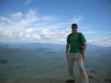
Algonquin and Iroquois 1/12/2008


First hike of the new year. Also, after spending a bit of cash getting outfitted for winter hiking, this was my first full blown, two to three feet of snow, honest to goodness "Winter" hike. Let me tell you what, this is a different animal all together! A bit more technical at times, more weight to carry, managing body heat, icy summits....but, even MORE rewarding! I know...You must think I am crazy. The first 3/4 of this hike was on snowshoes, the last 1/4 on crampons as everything turned to ice. The self portrait above is the me by the summit cairn on Iroquois, which is the smaller of the two mountains conquered on this day. Algonquin is the SECOND tallest in the state, and probably not a wise choice for your first full blown winter hike. I perservered though, and two socked in summits were my reward this day. Visibility on both summits was about 20 yards becuase we were IN the clouds and it was snowing most of the day. 2-3 inches of ice all over everything when we got above the tree line, as you can see. The self portrait was taken by a small family I happened upon on the summit because my hiking partners had already summited and were heading back down by this time. I had started to tire at this point, but watching the father of this family gather everyone around him to block the wind so he could test his blood sugar gave me new energy. Guess no matter how hard you think it is, it could always be harder! This one gave me the winter hike bug. I may someday try to become a WINTER 46'er, which is doing these 46 ALL in the winter. One challenge at a time I guess! Anyway, Great hike with just about no views at all. A few very quick looks was all. Oh, and the top photo is a picture of Wright peak which will be a target later, as we ran out of daylight to get there this day.
Monday, April 5, 2010
Street and Nye 2/9/2008

 Really, another uneventful hike. Just another pair of winter peaks to add to the list! These two peaks are fully treed, so not much as far as views. Especially since it snowed most of the day and the cloud deck was very low. Bottom photo is about the extent of the views for this day. Entire hike was on snowshoes. We had about 1-2 feet of fresh snow from a couple days previous, but thank god the trail was broken. Haven't had to break trail yet on snowshoes, but from what I hear, it makes the hike much harder. The snow on the trees made this an interesting descent, as everytime you would touch of lean on a tree, you would get a large amount of fresh snow falling on your head and going down the back of your coat. Another lesson learned though, and that is to make sure you have the right equipment if your going to take a hike out in this wilderness in the deep snowpack. One hiker had snowshoes, but they were designed for flat terrain and made it quite a challenge for him, especially on the descent. There was even one spot where he slid into a snow hole and his snowshoe got wedged in very very tightly and he needed an assist to get it loose. this was the hike I decided I would never leave anybody behind on these hikes. You never know what could happen. Also, it taught me that some people are just completely inconsiderate at times. I don't mean any of my fellow hikers either, and we'll leave it at that. It's kind of gross to talk about, and the people that were with me know what I mean.
Funniest part of this whole hike was on the way out, by the lake, I managed to stand in just the right spot as about a 20 pound glob of snow fell from the tree tops and hit me directly on top of the head, and missed the hiker I was talking to. Just my luck I guess. Well, just two more to add to the list of 46, and they count toward the winter 46 if I choose to do them.
Sunday, April 4, 2010
Tabletop - 2/24/2008


Another great winter hike! Top photo, I believe, is Mt. Marcy from Tabletop, bottom photo is the Marcy dam. Original plan was to do Tabletop and Phelps, but again, we were foiled by the short winter days and decided Phelps would still be there when we come back later. First time I have had the priviledge of being at the Marcy dam. Seen alot of pictures, but this was the first time I had seen it in person. Photos do not do this view justice. Seeing it in the winter was cool, but I was longing to see this in the summertime too (To come later!) Other than that, this was a very uneventful hike. Descent snow level, a good packed trail, moderate temps. Everybody had good snowshoes this time too. The weather was beautiful, the company was great, the climb was awesome. This hike brought my overall 46'er total to 16, and the winter tally to 5. Someday we'll also do something up here in the area of the dam as a camping trip. There are a few lean-to's around the lake, and it is just a beautiful place and central to several of the High Peaks.
Saturday, April 3, 2010
Phelps Mountain - 5/19/2008


Well, had Monday the 19th off and decided to take a trip up to the high peaks and bag a couple peaks I missed this winter due to the lack of daylight. The 2 target peaks were Wright Peak and Phelps Mountain. These were passed up in January and February hikes of Algonquin/Iroquios and Tabletop, respectively(More on these later!). Normally done with, as they are so close together, but daylight is at a premium these months. Anyway, the weather report said 30% chance of rain and 50 degrees, so I went for it thinking that 30% is a good low number. Well, having done several trips to the high peaks region, you would think I would have learned to disregard what the weather man has to say! I was on the approach road to the Adirondack Lodge and started to see sleet falling. Bah! I said. I have the warm clothes I need if it gets cold. After chatting with the girl in the shop at the Loj about conditions, I decided that I would attempt Phelps first, then if time permitted, I would go for Wright. Felt very good, made the first 2 miles or so in less than an hour. Arrived at the Marcy Dam and the snow was flying! (Bottom Photo) At this point, I figured I was already almost halfway to the Phelps summit, so I pressed on. Reached the split where Tabletop and Phelps trails part, and headed uphill. At this point, it was all snow and no more rain. Nothing was sticking at this point, but as I gained altitude, it started sticking high in the trees and gradually moved downward as I climbed. When I reached the summit, it was January type conditions. 30 MPH wind and about 20 degrees(Top photo). At this point, I added my winter shell and winter gloves and hat and was glad I convinced myself to add them to my pack back in the parking lot! Needless to say, with no views to speak of, I didn't stay long and was back down and at the Loj before 1:30pm. Since it rained/snowed the entire hike up and back(Rather muddy, I would add), at this point I was soaked and decided that another 5 miles and 2200 vertical feet to Wright Peak was not in the cards this day. All in all, a good hike that taught me that there is no substitue for being prepared for what these mountains can throw at you at any point in your hike. I was reassured of this when I ran into a pack of young folks at the summit that hiked up in track clothing and sneakers! I wondered later if they got down without anyone having frostbite or hypothermia! Never ceases to amaze me, some of the things you see while hiking these mountains. Anyway, this peak was a little over 7 miles round trip, and #17 of my 46.... 29 more to go!
Friday, April 2, 2010
Dix and Hough - 6/08/2008


Nine of us on this hike. We all agreed beforehand that only 4 of us were going to go over to Hough after topping Dix. After all the arangements were made, off we go. We started at the Round Pond trailhead and it was very hot and very humid. A bit of extra weight on me this day as I packed extra water expecting to need it later. And that was a good call. Drank every bit of it and then some after we got back to the trailhead after. Learned here that pacing yourself is very important in conditions like these. I believe it was low 90's and very very humid. Perfect weather for the black flies apparently, as they were out in force this day. This was the first time I have seen a slide up close. We didn't hike up the slide, but it was neat to stand at the bottom of it and look up, as in the first photo. The power of nature is sometimes awesome to behold. The slide is also the beginning of the serious uphill on this hike. This was some serious vertical gain. Worth every bit of effort though, as in my opinion, these were the finest High Peak views I have seen yet. I would say even or better than Gothic's views. Anyway, it was a bit cooler on the summit with a nice breeze to keep you cool and keep the bugs away. We sat for a bit and took in the views of Elk Lake and such and prepared for the hop over to Hough. The herd path to Hough on the Beckhorn was a bit tough to find, but once we found it, it was easy to follow. Tough herd path though. Very closed in, and I had the scratches and bruises to show for it a few days afterwards. The second photo above is from the Hough summit looking back towards Dix, which is hidden behind the prominent feature in the photo called "The Beckhorn". Having summited both peaks, we took the long trek back to the parking lot. My GPS told me A little over 18 miles and it took almost 12 hours on the nose. Toughest one yet. (So far...)
Thursday, April 1, 2010
Colvin and Blake - 6/15/2008


Another great mid-summer hike. Temperature was a bit more moderate on this one, but the bugs were just as bad. A bit bigger more diverse group of hikers too. It's always good to see a few different faces on the trips. My impressions of this hike beforehand was that we do 6 miles of it on a dirt road, so how hard can it be? Famous last words. Technically, I think this was one of the hardest yet. Alot of scrambling up and down for a good portion of the hike. This one is kind of deceptive also, in that standing on Colvin, Blake looks close enough to reach out and touch, but you have to lose about 800 feet of vertical and go up another 500 to reach Blake. Easily the toughest down and up between peaks yet. Large amount of vertical loss and gain in a relatively short distance. That usually means lots of rock scrambling and root grabbing, and I was right. Alot of spots that were tough to figure out and slowed us down quite a bit. I kind of like this kind of thing though. Makes it even more rewarding when you stand at the top and take in the views while you catch your breath and wipe the sweat from your brow. Only bad thing about this hike was I left behind my Leki trekking pole on the summit of Blake. Hoping that the gate at the AMR has it, but I since bought a new one to replace it, I'm not too worried about it. I bought the same one because I like the cane style handle on it. Has kind of a hook on it that you can use to pull yourself up in spots if you need to. Anyway, this is the last of the "Catch up" posts, so any hike from this one on will be posted in real time. Oh, and the top photo is the Ausable Lake from Colvin's summit, and the bottom one is the beginning of the hike on the shady Lake Road.
Wednesday, March 31, 2010
A Vacation..... - 7/23/2008 - 7/30/2008


I decided I needed a few days off from work and a bit of rest and relaxation. Booked a campsite in Wilmington Notch for a week, and off I go! Get there and the weather does not look good. I was able to set up dry, but it rained for the first day and a half of this trip. The second photo above is basically where I sat for the first 2 days of this vacation. In the chair under the tarp with my waterproof radio. it rained so hard, I wasn't even able to start a fire at this point. The first few minutes there, I hear rushing water from down below my campsite and am curious what the sound is. The first photo is what I found after a short hike to find the source. That's the west branch of the Ausable River with some minor flooding going on from a few days of steady rain. All in all, not a good start....But it gets better. What do you do on vacation in the northern high peaks? HIKE of course!!!!
Tuesday, March 30, 2010
Wright Peak - 7/25/2008


 Another catch up peak from the short days of winter. This was the first somewhat sunny day of my vacation, so I decided to knock this one out. As I said earlier, this is normally done with Algonquin and Iroquois, but we ran out of daylight. That said, this was a spectacular hike on a beautiful clear day. Places in this hike that were normally just a trickle of water on the rocks turned into full blown waterfalls from all the rain in the previous week. Basically, this entire hike was in a creek bed it seemed. Reading about the B-47 that crashed here long ago is one thing, actually seeing the spot where it sheared off rock from this mountain and seeing the wreckage is totally another. All 4 people aboard killed, only three of them recovered. Sobering, and makes you reflect on just how short life can be. Googling Wright Peak and planecrash will give you the whole story. One photo above is the summit plaque at the sight of the crash. Another photo is summit self portrait with the village of Lake Placid in the background. Another of these photos is one of the larger chunks of wreckage at just below the summit. It's good to see that even the immature and vandalous scoundrels leave this wreckage alone, as even the smallest pieces are undisturbed. Well, the only bad thing about this hike is that basically, this trail set is a freeway. I was shocked at the number of people here on a Friday. But, they were all headed elsewhere I guess, as I had this summit to myself for at least 30 minutes. By the time I returned to the parking lot, all 3 lots were full. All that said, this hike was a 6.5 mile primer for the big one to come tomorrow......
Monday, March 29, 2010
Donaldson, Emmons and Seward - 7/26/2008


 16 miles. over 4000 feet total vertical. 3 peaks. Pretty much says it all, but there are so many other stories to go with it on this hike. Weather was 50% chance of showers and thunderstorms in the afternoon which pretty much tells you they have no idea what it's going to do. Got to take it serious up here though. The day starts out at the Corey's Road trailhead brilliant and bright and sunny. Not a cloud in the sky. We figured if we had until the afternoon, we would be safe. So of we go. 6 on this hike including a couple I didn't expect to be there. The first 4 miles or so of this hike are relatively flat with no suprises, but we did get a preview of the mud that was to come. Unfortunately, I also got a preview of the infighting that was coming too. It seems that some of the folks on this hike just don't get along, and they can't put there differences aside for 8 or 12 hours and they have to drag it along and put it on display for everyone. I got pretty upset late in this hike and basically told people to stop it. Real simple. I don't want to feel like I'm at work. All of that said, I enjoyed this hike immensely as it was very very rewarding. 7 miles or so to the top of Donaldson, then a 2 miles out and back with about 500 feet of elevation to Emmons. Short break to eat, then back to Donaldson. It was at this point that we started to see some clouds rolling in. One more out and back. We can do it! 2 of the six decided they had had enough, 4 of us pressed on. So, another 2 mile out and back and about 500 feet of vertical or so. We had really got slowed down by the roughness of some of the herdpath and the MUD. I capitalize it on purpose because, man, it was the nastiest boot sucking mud I have ever encountered! So we manage to hit the top of the final mountain, Seward, and RIGHT as we did, we hear thunder in the distance and see ominous looking rain clouds actually BELOW us forming between the peaks. It was really weird to see. Anyway, we all slapped on some rain gear in a big hurry and booted out of there quick. Nobody wants to be on a high peak in a thunderstorm. Probably 300-400 feet down Seward it started to rain. There is no greater motivator when your hiking than thunderstoms! I had such and adrenaline rush from the fear, I could have hiked 6 more peaks! Also, at this point, we were pretty much soaked as we headed back to Donaldson for the descent back to the trailhead. Partway down donaldson, the rain stopped and the sun came out. But as I said, we were already soaked and covered in mud, so we gave up trying to dodge the mud at this point. When you get to the point that your boots are full of water, it just doesn't matter anymore. With the hard work over, we just needed to make the 6 miles back out to finish this long rewarding day. This was the first time I had heard thunder on a hike and I did not like it. Hope to never hear it again. Anyway, at the end of this hike, the cold beer tasted especially good, and the beef stew I had made for dinner was especially tasty. All in all, a very successful day for all 6 of us!
Sunday, March 28, 2010
Whiteface and Esther - 7/29/2008


 Last of the hikes on my vacation. Decided that the weather was not going to cooperate to do Allen on Wednesday, So Whiteface and Esther were going to be the target on Tuesday, and I would pack up and leave for Catskill after these two. The weather looked bad for Wednesday and I did not want to pack up in the rain. Took off from the trailhead about 8:30am after staring at Whiteface all week from my campsite. Impressive sight. Though this is not the tallest of the high peaks, I almost want to say it's the most vertical gain of all of them. Started at 1300 feet and finished at 4800. Most of the high peaks I have hike so far start around the 2000 foot range. The distance one way is 4.7 to Esther and 5.2 to Whiteface. So it seems to be 3500ft one way of vertical to Whiteface alone. Add another 200-300 for Esther. Easily the most on a single or double peak yet. Pretty gradual though over the 5 miles with the last mile or so being kind of intense. Crapiness comes when you see construction signs at 4000 feet and hear Harleys and cars shortly thereafter. This peak is a tourist haven that allows people to drive to 50 feet or so from the summit and take an elevator the rest of the way to the summit. I'm all for allowing folks who can't hike the 5 miles uphill to experience what it's like to stand on a high peak, but the flood of flip-flop wearing complaining people just soured me totally. Can't complain though. This was #5 and #6 for my vacation - COMPLETELY a success! 10.4 miles round trip and a total of about 4000 feet of vertical. After this, I was totally drained, tired of sleeping on the ground, and weary of campfire food. Not to mention, my left knee has decided that I am working it too hard. Packed up and got back Tuesday night to a nice barbecue dinner, sore quadriceps, and a knee that was twice it's normal size. For the week - About 34 miles, approximately 10,000 feet of vertical and 6 mountains. All in all a huge success!
Friday, March 26, 2010
Basin and Saddleback - 9/07/08


Awesome! Not much more to say about this one. For over a year I have been reading about the "Cliffs" of Saddleback. The more I read, the more fear I had of actually tackling it. Thought about just doing Saddleback from the other side solo to avoid them. Well, got an email from a friend that said she wanted to do these INCLUDING the cliffs, and I could not pass it up. Everything you read puts a fear into you that makes you think it is entirely perilous. I thought over and over about it and decided that if it was so dangerous, you would read many stories about people falling off it and getting hurt or worse. I was right. The hike was routine up to that point. Almost 8 miles in and after summiting Basin, you come up to this rock climb that I read was labeled "Grade three non technical" which I guess means you don't need any equipment to tackle it. Again, right. Although you are very exposed on a rock face and any fall from any point would absolutely ruin your day, if you are smart and careful and deliberate, this is no problem at all. The way you have to approach it and analyze every single step and handhold was awesome. Oh and if your afraid of heights, this ain't for you! I did this, enjoyed the hell out of it, and it was such an adrenaline rush, I would do it again! Bottom photo above is the view of Saddleback from partway down the backside of Basin. The place we have to climb is slightly left of center of the summit, left of the treeline. You can actually see the trail in the photo just below where it comes out of the trees. This is a watershed moment for me, as this was the only one of these that I had been afraid to do. After doing the cliffs, Basin almost seems like an afterthought. The trip totals - Just over 14 miles, 3600ish vertical, 2 summits and one HELL of an adrenaline rush! I so enjoyed this that I would do it again and again! Top photo is Basin summit self portrait with Mt. Marcy in the background.
Thursday, March 25, 2010
Lower Wolf Jaw - 2/28/2009


Better known as "I BROKE A HEEL!(bale)" Was hiking along nicely in the WolfJaws notch and the heel bale on my snowshoes decided to fold forward and break off. Not really a big deal, just makes me realize how nice this small accessory is. If you get snow shoes, get them with this. Trust me, once you try them you will never go back. Anyway, this hike makes #30, as you can see from the photos. thats actually me signing 30, not some weird Adirondack hiker gang signage. Relatively easy hike, but with winds predicted to be 30MPH or better, was worried what the summit would bring. Again, as you see from the pics, summit was sunny, warm and calm. No wind whatsoever. So we took in beautiful views all around, the sun, and the deep azure blue sky. You know the views are going to be spectacular when you see that color blue on the way up. Nice hike with nice people. I was impressed with Jim's preparation for this hike, as we were able to have hot tea at the summit after he set up his stove and made hot water! Just all around great stuff, this one was. Great folks, great hike, great views...doesn't get much better than this one....
Tuesday, March 23, 2010
Redfield - 3/15/2009


 16.5 miles, 3200ft vertical by my gps. A tough one because you have to hike about 7 miles just to reach the unmarked uphill portion of these. This was very rewarding though. Some of the most spectacular views so far. Not too bad for such a remote set of peaks. We had the intention of doing Cliff with this one, but this days situation did not allow us to conquer that one too. Actually kind of good, as I really have to see this Avalanche Lake in the summer. It's all good, as I say these mountains aren't going anywhere any time soon. A success in all ways, as I added another to both my lists, 46er and W46er. Anyway, pic descriptions, in order top to bottom are as follows: 1. Allen Mountain - Another of the remote high peaks. Infact, THE most remote of them all. 20 Miler round trip. That will be this spring/summer for sure. 2. Summit self portrait - Self Explanatory. I got to bet that the wooden sign is normally 6 or 7 feet off the ground. We were standing on at least a few feet of snow. Also, thats Algonquin and Wright over my left shoulder. Lots of fresh snow on it as you can see. Looks like it rained/iced below 4000 feet and snowed above that. 3. Avalanche Lake - This was a Harrowing experience, as the temps were pushing 50 and the ice was soft and sagging in spots. If you look close, you can see our fresh tracks all the way to the right, as we were hugging the edge just in case. Aside from the fear of falling through the ice, the views here are SPECTACULAR! I guess theres a reason they call it what they do. So, this makes 31. Hopefully with any luck, we'll finish sometime mid/late summer. Next up if the weather permits(#32) - Macomb Mountain.
Monday, March 22, 2010
Mt. Skylight Solo - 5/13/2009


 This was going to be an ambitious three peak solo.(Skylight/Gray/Cliff). Your eyes always take more than you can eat at a big buffet though....I was glad to be back in the big hills finally after a hardcore stretch of overtime at work. First thing I encountered was my favorite friend, Adirondack mud. If I had known what I was in for, I would have welcomed it with open arms on this day. Top photo was after the first 2 hours of this solo journey. No matter how much you try to dodge it, you'll always find a couple shots where you sink in up to your ankle. As the hike progressed, an even more insidious enemy presented itself. The 4-6 foot deep snow with a 6 inch wide spine to walk on. (See 2nd photo) Early on it was easy, but as the day wore on, it softened up and became posthole hell, especially near the herd path for Skylight. For those not in the know, postholing is when you break through the hard crust and sink in up to your knee/hip. I must admit, I was not prepared for what I was battling, and I'm not sure you CAN prepare for these type of conditions. Snowshoes MIGHT have helped speed things up. Left the trailhead at 6:30am, arrived at the summit a bit after 12:00pm. WAY too long to do one mountain because of the conditions. Had every intention of doing at least Gray with this one, but when standing at the herdpath to Gray at 2pm, and seeing that it was also half covered with snow, I figured it was going to take all my effort to get out by dark. Hindsight being what it is, I am glad I made the decision. This was my first trip to Lake Tear of the Clouds and four corners, and it was cool. It never ceases to amaze me how these mountains can reward you one minute and humble you the next. My experience is, if your standing at an unmarked herd path and questioning whether you should...Don't! Last photo is of Lake Colden, which I experienced for the first time on this day. Georgeous and serene beyond comprehension. So...what I thought was going to be three peaks this day turned out to be only one because of the conditions. All good, as I want to come back and do more and not become an accident report or a statistic. A decent reward, muddy shoes and pants, torn up hands and arms from grabbing trees while hiking downhill on the snow, and #32. As usual, a sucess....
Sunday, March 21, 2010
Gray and Cliff 5/30/2009


A couple of self portraits on this post. One taken by the two guys I leapfrogged with all day on the way to Gray. Was kind of cool, because I saw them pull into Upper Works right behind me and I asked where they were going. They said Gray and I said Me too! Probably would have hiked the whole day with them and Frodo the Corgi, but one of them realized at the 3/4 mile mark that they had forgotten their food and had to go back to the trailhead. Second photo I had to take myself as I was alone on Cliff. GPS said the first bump I went over on the way to the summit sign was about 6 feet higher in elevation. I think they need to check this LOL! I thought the sweat beads and pine needles stuck to my forehead were a nice touch. This was the first hike I had taken a serious header into the woods. I've learned to just go with it and not try to catch yourself or rescue somehow unless your facing a big dropoff. Couple of scrapes on the hands and a sore shoulder is all I got out of it thankfully. Made the hike out all the more fun, as the shoulder was barking the whole way. Being that this was a weekend, lots of people on Marcy, lots of people in the leantos. Had the good fortune of two rainshowers, both right as I summited each peak. Between that and the rain the last two days, this was hiking in a streambed most of the day. The herdpath to Cliff was an absolute quagmire, at the bottom and at the top. Cliff, although not technically a 4000 footer, is very steep, and I had more vertigo and fear going DOWN this one than I did going UP Saddleback last fall. One wrong move and you will be going for a ride down the rocks. Top photo is Mount Marcy encased in clouds from Gray. Whoever said there's no views from Gray was wrong! Anyway, any jaunt up some high peaks where you can make it out in one piece is a great success. This was 33 and 34, and a nice primer for the three peak hike next weekend known as "The Santononi Range"! Details for this one - Two peaks, 17.9 miles, cumulative ascent of 5214 feet. Not too bad and I am feeling it today....
Saturday, March 20, 2010
Santanoni Range - 6/06/2009


What better way to enjoy some time off than to go to the 3 mountain range in the high peaks that nobody likes! Everything I have ever read and everyone I had talked to about it paints this as a miserable hike. I personally didn't think it was all that bad. It certainly was muddy in spots and we did have to cross a couple full fledged swamps, but overall, not as aggregious as everyone makes it out to be. This one is similar to the last two posts, in that it takes a serious amount of climbing to reach the herd paths to the three mountains. We had started at about 1800 ft of elevation, and got to what is affectionately called "Times Square" at 4300 feet of elevation. We chose to do Panther peak first, as it is an easy out and back for the first peak. Bottom photo above is the overlook on Panther looking DOWN at target #2 - Couchsachraga. Actually lost 800 feet of elevation and picked up 320 or so to get to Couch. Bad thing is, you have to climb back up the 800 feet to get back to Times Square so you can go to finishing peak, Santanoni. That one is fairly easy, 3 or 4 hundred more vertical, then the uphill part is done. At this point, the only part of me that hurt was the balls of my feet. Seems I need thicker socks or better insoles. The last two hikes have beaten up my feet. Regardless, we hit the top of Santanoni at about 3pm which was really good time. No doubt about getting out in the daylight here. We decided to use what is affectionately called "The new-old trail". Probably called that because at one time it was not regularly used because it was on private land. It allows you to not have to go back to Times Square, and cuts some travel distance off the trip out. Only problem is, it is a very steep downhill. We even had to use a rope someone left behind to kind of rappel down a small cliff. Top photo is the example of the cliff we had to descend. We had beautiful weather all day, sunny most of the time, nice breeze, no rain. Black flies were out in force this day. Not bad as long as we kept moving or the breeze was up, but they were out for sure. Even on the summits. Middle photo is the less than flattering summit photo on Couch. I think I need to work on the reducing the gut more. LOL Anyway, Particulars for this hike - 15.2 miles, 5067 feet of cumulative vertical gain, and three more peaks to the total. And the only thing on me sore or painful are the balls of my feet. For SURE in summertime shape now. Now at 37, and only 9 left! Finally in single digits....
Friday, March 19, 2010
Haystack - 7/19/2009


 Well, this was the first time in a long time that the weather had cooperated and coincided with my time off. Although it wasn't a perfect forecast, I decided to do this one anyway. Tried something different on this one too. Traveled to Lake Placid the night before and stayed the night. This allowed me to sleep until 6am and take my time getting to the trailhead. Typically, leaving from Catskill, I was up at 2:30-3:00am waking up all the neighbors on my way out. Made for a long day and I more often than not didn't get enough sleep and had upset neighbors. It worked out VERY well. I hiked stronger and wasn't quite as tired at the end when I got home. As far as the hike goes, I was solo on this one. Had not decided what I was going to hike until I had talked to a friend the night before. I finally decided to go with a hike that had views. It had been too long since I had awesome views, and decided I needed some. We start from the Garden trailhead in Keene and head for the John's Brook Lodge. From an earlier post, thats the neat little outpost 3.5 miles into the woods in the High Peaks. I arrived at the lodge just after they had served breakfast, and all the folks staying there were either off hiking or prepping to leave, as you see in the first photo. One of the few times in everyday life that a crowd doesn't bother me. People were all chatting about yesterdays accomplishments and todays targets. Not often in my life I can stand in a crowd of people who all get this... Anyway, I had been looking forward all morning to get the weather report at the JBL, and photo 2 shows what I read. The rest of this hike was bug free, relatively cool, and partly sunny for the most part. It took over 8 miles of hiking to finally hit the first bump of 3 that are the summit area of Haystack. Third photo is what I saw when I finally reached the first bump. It was quite a fight to get to the top. Obviously, tallest bump is the summit of Haystack. There are a few spots along the ridge that are steep and rocky. Worth all the work though, as you can see by the summit photo (#4). Thats Gothics in the background I believe. The hard part of this one was the distance. The climbing was mostly gradual except for the last mile or so. A nice leisurely walk in the woods and #38. GPS particulars on this one - 16.5 miles, about 4700 feet of vertical gain. Only 8 more to go....
Subscribe to:
Comments (Atom)